But, Before We BeginThe last kids of the kidding season are on the ground so now it’s time to turn our attention back to land development and planning. We’re now in March and the time to get the annual plantings in the ground is at hand. In order to maximize our efforts and yields we’ve got to move from sketching to cementing out ideas as far as the overall farm layout is concerned. Must Bee Kiddin’ Farm is just over ten acres. Right now only one person works it full-time and a second joins in to help bear the workload on weekends. Ten acres may not sound like a very big spread, but when you consider that it’s undeveloped and densely wooded, it’s easy to get overwhelmed. The best way to get past those feelings of overload is simply to just get working. Energy begets energy. Momentum over meditation! With that in mind, it’s important to have some solid action plans fleshed out. At this stage of the game major mistakes are pretty hard to make since we’re still pretty much in sandbox mode. As we’ve stated before, we’ve adopted the basic tenets and guiding principles of Permaculture in the development of Must Bee Kiddin’ Farm. At the center of Permaculture is a design plan that utilizes is zonal development. Permaculture design makes use of a five zone system and this drives the development and layout of the property. The zonal layout scheme Permaculture emphasizes helps with focus and keeps the thinking centered on the big picture. But, before even delving into any Permaculture zone planning we must pull back one frame of focus and look at the big picture. Before laying out any zones it’s best to chart the land concentrating on land features and the major weather patterns at play on the land. 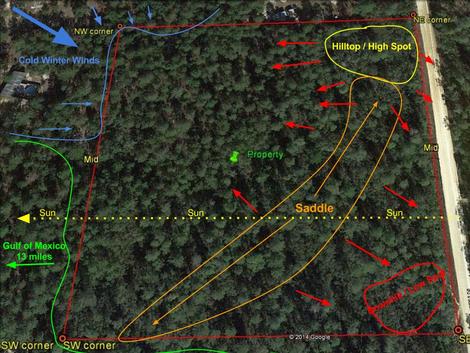 Land features and weather patterns on Must Bee Kiddin' Farm. Land features and weather patterns on Must Bee Kiddin' Farm. This picture illustrates the prevailing weather patterns by season as well as highlights the main topographical features on the Must Bee Kiddin’ Farm. This property picture is from 2013 and is accurate up to the time of purchase. Nothing had been done to the property or adjoining properties until the time of our purchase. The first, main feature of the farm is the fact that it’s pretty much a square. It aligns with the compass as the top property line is north, the right is east, the left west and the bottom property line is south. Thus the track of the sun is from right to left.
As I’m writing this, today’s (3/1/2015) temperature was pushing eighty degrees (F). That being said, we just had an overnight low temperature in the low twenties less than four days ago. Subtropical means contending with hard freezes just about every year. This is why this weather and land feature map is important. In not only paying specific attention, but mapping the prevailing seasonal weather patterns and land features, extremes can be mitigated. In other words, if we pay close enough attention to the lay of the land and which way the winds blow we can use this to our advantage when it comes to land development. Microclimate identification and exploitation become critical for extending growing and increasing yields. The hilltop situated in the northeast corner of the property is the highest point on the farm. The section marked saddle is a ridge that runs to the southwest and joins with another hilltop that is situated on the neighbor’s property to the south. The elevation of that saddle is about ten feet with low spots in the southeast and, to a lesser extent northwest and southwest corners of the property. With cold winds blowing in from the northwest, the saddle acts as windbreak. Cold northwest winds are mitigated by that saddle and the southeast corner of the property becomes favorable for more tropical plantings such as bananas. The weather map also becomes important when deciding where forest stands need to be kept, thinned or bolstered. If cold winds sweep in through the northwest corner, that’s a good place to consider a plantation of longleaf timber pines to stand guard against Jack Frost’s devious notions and Old Man Winter’s bitter bite. On the flip side, thinning the southwest and southern lines becomes important. Being in coastal Florida means hurricane season is always a consideration. So there it is, Must Bee Kiddin’ Farm’s weather and basic topographical map. After mapping the basic landscape features and considering the prevailing weather patterns we’re now ready to get into the meat and potatoes land development plan. Developing this weather and land feature map was a pretty simple exercise, but definitely time well spent. In the next installment of the Must Bee Kiddin’ Farm development plan we’ll talk Permaculture zone development. //mr
0 Comments
Leave a Reply. |
About UsIn 2014 a couple of 40-somethings decided to make a change. The purchase of 10 raw, pine scrub acres along Florida's Nature Coast started it all. This is that story. Archives
March 2018
Categories
All
|
 RSS Feed
